Marine erosion is destroying beaches and homes along the coast of São Paulo state; public works projects seek to combat more frequent storm surges
12.jun.2018 - 02h00
{{lang=1|por,//staging.arte.folha.com.br/ciencia/2018/crise-do-clima/litoral-paulista/|esp,//arte.folha.uol.com.br/ciencia/2018/crisis-del-clima/litoral-de-sao-paulo/}}
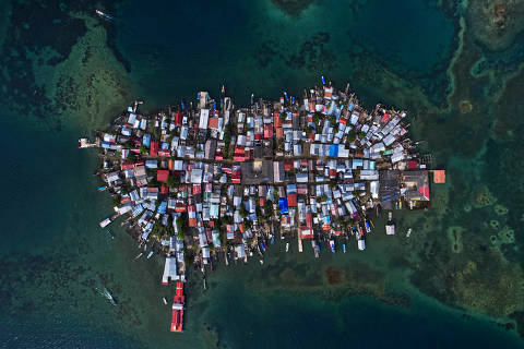
When water enters the stilt houses of the Mangue Seca favela in the northwest part of Santos, "you know it's time to get out," says Dyennifer Aparecida da Silva, a 35-year-old unemployed cleaning assistant.
"The water comes up to your ankles, sometimes all the way to your knees," she explains. "After that, rats, cockroaches and mosquitos start to come in, which are hard to bear. Things can be as clean as a whistle, but the rats will eat your food."
The northwest part of Santos has stretched out over an area of mangroves that is only 1.4 meters (about four and a half feet) above sea level. During the 1950s, a drainage system of canals was constructed in order to support agriculture in the area. And though the community is 15 km (9.3 miles) from Ponta da Praia, floodwaters reach Mange Seco via the canals during high tides or particularly strong tidal surges.
"What they call a mini surge there at the beach can sometimes be a tsunami here," says da Silva.
{{imagem=2}}
{{imagem=3}}
As she walks the alleyways of the community, she greets neighbors and family members while balancing on wooden planks with gaps big enough to see the sewage running beneath. Da Silva has five kids of her own but she has also helped raise some 12 or 13 other children in the neighborhood.
Da Silva, her sister, Jane Maria Vieira, and ten other women lead the community's residents' association, which has been lobbying the Santos city government for publicly-subsidized low-income housing.
While they await the possibility of more sturdy dwellings, the entire neighborhood has been working to raise the houses, adapting them to more frequent –and higher– floodwaters.
To stay ahead of the rising water, residents punch through the floorboards to make room for new pilings that support the houses using longer lengths of wood. Each new piling is placed through the center of old truck tires that are positioned in the sludge at low tide. Finally, the tires are filled with rubble, sand and gravel in an effort to stabilize the structure. It is an engineering job "worthy of NASA," says Vieira.
{{info=2}}
"We want a place where we don't have to worry about surges, high tides, wind or fire," she explains. "Some look on us with pity; they think we're here because we want to be. But there are many here without work who aren't able to pay rent."
That is the case of 65-year-old Antônio Roberto "Seu Toninho" da Silva and his neighbor, Silva Araújo, 28. Both men are unemployed and make a living doing odd jobs. Their two houses are situated at the end of an alley and are distinct from other neighboring structures. Seu Toninho's slants at an angle, the rear section of the house sagging down into the water. Araújo's dwelling, much lower the than others, practically touches the water.
"I already lifted it one and a half meters [nearly five feet], then 90 centimeters [three feet] more, but I'm going to have to raise it again," Araujo says. "When a surge comes, the water will bring everything else in with it."
{{imagem=1}}
The tidal surge season stretches from April to September. Extratropical cyclones form between Argentina and Brazil's Rio Grande do Sul state and advance toward the southeast of Brazil, generating huge swells and elevated sea levels.
Such surges are a natural phenomenon, according to physicist and meteorologist José Marengo, who heads research and development at the National Center for Natural Disaster Monitoring and Alerts (CEMADEN).
But storm surges have become more frequent –and more intense– with global warming. Warmer sea water leads to stronger winds which, in turn, generate larger waves that penetrate deeper into the city's infrastructure. These waves get an additional boost from rising sea levels caused by melting glaciers and a larger volume of heated water.
According to the Intergovernmental Panel on Climate Change (IPCC), a UN body, global sea levels have risen 1.7 millimeters per year over the past century. Tidal data from the port area of Santos show a rise of 1.2 millimeters per year over the past 30 years –a total of 3.3 millimeters (1/10th of an inch)– with an upward trend over the past decade. Factors such as ocean circulation patterns and ground subsidence (how much the earth shifts downward relative to the sea level) can influence sea level measurements and may help explain why the rate in Santos is lower than the global average.
{{video=2}}
Project Monopole estimates that these levels could rise to between 18 and 23 centimeters (seven to nine inches) by 2050 and 36 to 46 centimeters (14 to 18 inches) by the year 2100.
The project, coordinated by Marengo and financed by the state of São Paulo's Foundation for Research Support (FAPESP), evaluated three coastal cities –Broward, Florida (United States), Selsey (United Kingdom) and Santos– and how they have adapted to climate change.
The areas of study in Santos were the Ponta da Praia, an upscale neighborhood popular with tourists, and the impoverished northwest zone where Mange Seco is located. And though the two neighborhoods are in stark contrast with each other in terms of the socioeconomic status of their residents, each is vulnerable to rising sea levels and extreme events such as storm surges. Both have experienced impacts of climate change, says Marengo.
{{info=3}}
Designed by architect João Artacho Jurado (1907-1983), the Enseada building is a beachfront property that has been a frequent victim of tidal surges in Ponta da Praia. Small business owner Patricia Castaldino Amado, 41, found her car completely submerged in the building's parking garage –along with eight other vehicles– in a 2005 incident, the worst storm surge on record in Santos.
After that, the building installed an anti-surge alarm, which is activated by the concierge on duty. Every Friday at 11am the system undergoes a high-decibel test.
When a storm surge hit one early morning in April 2016, the alarm functioned properly but Amada was slow to awaken. She was one of the last to get her car out of the garage. With the water already high in the street, the engine stalled.
"I don't have a car anymore," she says. "I just use Uber. People who live on the coast have to adapt, right?"
{{imagem=20}}
Celia Regina de Gouveia Souza, a researcher at the São Paulo State Geological Institute and a participant in Project Metropole, manages a tidal surge database for low-lying areas of Santos and has observed a strong upward trend since the late 1990s.
"The 2000s and 2010s had more storm surges than the entire previous century," she says. In 2010, 15 such events were recorded, compared to a maximum of four per year between 1960 and the early 1990s.
The Metropole Project estimates that adapting Ponta da Praia and the northwest zone of Santos to climate change would cost close to $80 million. The work would include the recovery of the mangrove swamp area in the northwest, construction of storm surge walls in Ponta da Praia and improvements to the system of floodgates and pumping stations.
{{info=1}}
Maintaining the status quo could cost Santos $300 million or more. Even this is a conservative estimate, however, as the figure only takes into account the value of losses for beachfront property.
"A key part of the project is the perception that there is a problem and what can be done to resolve it. The research did not reveal some previously untold truth, but it did give the initial push for the population to think about adaptation," says Marengo.
"The worst that could have happened was someone shows up claiming climate change is a lie –a crazy scientist thing– or the city government saying global warming has nothing to do with it," the meteorologist continued. "But, to the contrary, we had the full backing of the local authorities and would not have been able to conduct the studies otherwise. Now it's up to them."
{{video=3}}
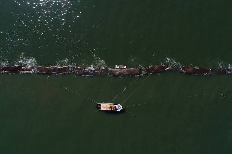
{{imagem=4}}
A first response, says Marengo, is the installation of a row of 49 massive sandbags in the sea at Ponta da Praia as a way to reduce the force of storm surges while mitigating coastal erosion in the area.
This stretch of coastline and beach areas is disappearing. Trampolines, soccer fields and light poles that were here decades ago have vanished.
With less sand, waves crash on the beach and the main avenue with greater force. The storm surges, in turn, sweep away the little sand that remains in an already denuded boardwalk area.
The underlying causes of erosion in Ponta da Praia result from human interventions as well. Celia Souza of the Geological Institute says that the problem has worsened since the 1930s, when the main boardwalk avenue was paved on top of the beach. Underwater sewage pipelines and infrastructure have also taken a toll.
{{mosaico=1}}
A number of factors have prevented Ponta da Praia from vanishing altogether. For decades, the city has reinforced the area with sand, which sea currents draw westward toward canals 1, 2 and 3 where the beach is wider. In addition, the city is a bit of a sand trap from Praia Grande, Peruíbe and Itanhaém all the way to Santos Bay. The water emerging from the underwater pipes and drainage canal 6 also keeps the currents from carrying the sand from the beach out to sea. Finally, wreckage from a ship that ran aground at Ponta da Praia decades ago helps buttress the sand there.
Since 2010, erosion has worsened due to the widening and deepening of the port's shipping channel. In an agreement signed with the Federal Public prosecutor's office in December 2017, the São Paulo Docks Company (CODESP) admitted that dredging may have contributed to the increase in wave energy.
CODESP has pledged to adopt recovery measures to mitigate and prevent the effects of coastal erosion on Santos Bay. The agreement stipulates that any construction work may not not use rigid materials, which will allow for easier adjustments in case of problems encountered along the way. The plan also recommends the huge sandbags –dubbed "geobags"– as an option.
{{info=4}}
The resulting structure, the first of its kind in the country, had already been tested in Australia, Mexico and South Korea. Unicamp professor Tiago Zanker Girelli, who works on coastal engineering projects, initially suggested the idea with colleagues as a counterproposal to the city's proposition to construct a four to five-meter high (13-16 feet) breakwater from the port channel to canal 4.
"We found the idea of a breakwater wall to be almost too impactful. It could solve the storm surge problem, but it would also put an end to the beach as Santos residents know it," says Girelli.
The installation of an artificial reef built with "geobags" was completed in April, just in time for the storm surge season. The price tag for the barrier was roughly $780 million, with all of the funds coming from the agreement between CODESP and the public prosecutor's office. "If it ends up working, we'll scale it up," says Girelli. "If it doesn't, we'll just rip up the bags and return the sand to the beach."
There are already indications this won't be necessary. According to Girelli, the artificial reef is accumulating sand, a good sign. Still, he says it's still too early to celebrate: "We need to see if the structure will survive the storm surges this season. It could be as big as 2016 and sweep it all away."
{{imagem=10}}
February of 2019 should offer some answers to the following questions: Will the artificial reef contain the sand and widen the beach –especially when there are surges? Or, will the tidal swell continue siphoning off sand into the harbor channel, never to return?
Girelli and his team continue to monitor Ponta da Praia and neighboring stretches of sandy coastline. "It's no use robbing Peter to pay Paul," he says. They try to forecast how sandbags might be deployed in the future as they continue to combat the upward trend in heavy storm surges. "Will the bags keep working with bigger waves? Will we need to fill them with more sand"?
Small business owner Patricia Amado lives directly in front of the sandbag project. She has heard many people predict that by 2020 the sea will have swallowed the entire beach. "So far it hasn't happened, but the beach where I took my son to play 15 years ago isn't there anymore," she laments. "Forty years from now I don't know if there will be a beach in Santos."
{{imagem=12}}
{{mosaico=2}}
{{imagem=13}}
Geologist Celia Souza has been monitoring the coastal erosion of São Paulo beaches since 1992. Every five years, she updates an erosion risk map.
Urban beaches with a high risk of erosion are likely to disappear, she says. Chances are even greater with rising sea levels, more extreme weather events and poorly-planned public infrastructure projects that impact the beaches and siphon away sand.
{{info=5}}
"Every time I visit these areas I see a different picture," she explains. "It's an image of destruction, but it's always different." In each of these coastal locations, Souza seeks to identify the causes of chronic erosion in order to evaluate the best recovery measures.
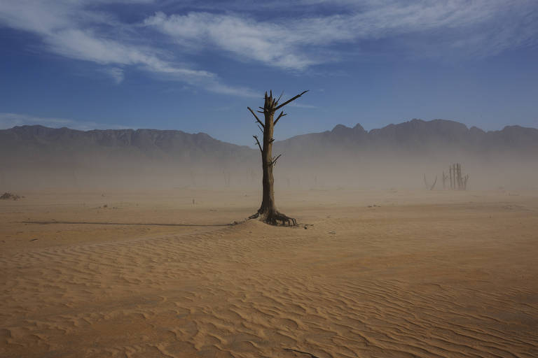
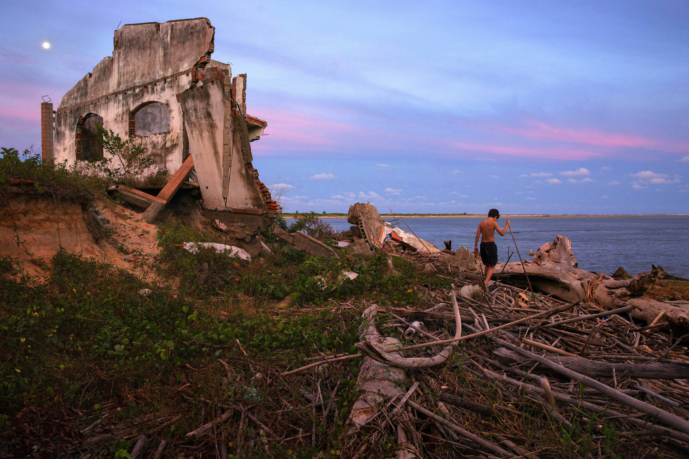
Along the south coast of São Paulo state, in Ilha Comprida and Praia do Leste, the remains of homes litter stretches of the area, as if a hurricane had blown through. They were built miles from the water, but the sea still reached them.
{{imagem=16}}
Souza says the process here is different from that of Santos. The landscape remains mostly in its natural state with little evidence of human intervention. "There is a constant push-and-pull of unstable and unpredictable coastal dynamics, with a lot at stake," she says. "It's sea, rivers, lagoons, rains, waves, extreme events. When sandy areas grow larger, everyone's eyes get wide and people come in to build houses. When the beaches erode, everything goes away."
Retired accountant Albino Souza, 70, bought a house in Praia do Leste in 1998. "I didn't come here for a few years," he says. "When I arrived in 2010, the house was there, swallowed up by the sea," he recalls, indicating a spot 50 meters ahead where the wreckage of homes can be seen in the sand.
In December, Souza bought another house in Praia do Leste and moved in immediately, much to the chagrin of his children. "They say I'm crazy, but nobody comes here and I like the peace and quiet," he explains. "For me, it was a good disaster."
{{imagem=11}}
57-year-old homemaker Sonia Maria Santos Carvalho has also lost property to erosion. She owned two beachfront houses, the remains of which can still be seen.
Carvalho lived in the first one for 12 years. "It wasn't safe. It was just made of tile," she says. "When the south wind blew, the whole house would shake, which scared us a bit. I already had a history [of other houses destroyed], but mine was quite far from the sea when I first arrived. I didn't think it would happen. But then it did."
She spent four years in the second. "This one hurt to see go," she says. "Three good rooms with flagstone floors. A wonderful house. When the sea hit and the pipes burst, there was nothing else I could do."
Carvalho spent three months living with friends. Then her name was selected for a home in a low-income housing lottery, this time far from the sea.
"Now, I think I'm safe for the foreseeable future," she says. "They say the sea is coming in, that Ilha Comprida is going to fall off the map. I think this gives me time to go up there [pointing toward heaven] before it happens. I certainly hope so."
{{imagem=15}}